Building a Resilient PNT System? 5 Key Steps to Follow

Positioning, navigation and timing (PNTPosition, Navigation, and Timing: PNT and map data combine to create the GPS service.) solutions are at the heart of critical military operations, powering everything from precision missile defense systems and warfighter navigation to Intelligence, Surveillance and Reconnaissance (ISR) data management. Although GPSGlobal Positioning System is a navigation satellite system. See also and GNSSGlobal navigation satellite system (GNSS): A general term describing any satellite constellation that provides positioning, navigation, and timing (PNT) services on a global or regional basis. See also signals in general are the most established and primary PNT reference sources, they have well-known vulnerabilities and limitations that require protection and mitigation. Resilient PNT is a convergence of technologies to improve the reliability, performance and safety of mission-critical applications in the air, on land and at sea.
Selecting the best Resilient PNT solution for military applications might seem complicated, but answering a few key questions can help define requirements. The most important objective is to ensure that trusted, accurate PNT data is available to warfighters so they can have confidence making decisions and can continue operations, even in contested or GPS denied environments.
- Determine the Application
Air, land or sea? Static or mobile? In which operating environment will the solution be used? Is it timing-based only, or is positioning and/or navigation involved as well? Each domain has its unique set of requirements, including factors such as vibration profiles, SWaP (size, weight and power) limitations, ruggedization parameters and the level of GPS jamming and spoofing tolerance required. The more defined the application, the more specific the requirements- resulting in a solution that performs well and isn’t over-engineered. - Which Outputs Are Needed?
Understanding output requirements is an important step in defining the most effective PNT solutions for each application. For example, if outputs such as IRIG, NTPNTP, or Network Time Protocol, is a widely used networking protocol that enables computers and devices to synchronize their system clocks with a reference time source. It ensures accurate timekeeping in computer networks by allowing devices to obtain precise time information from NTP servers, which are typically synchronized to highly accurate atomic clocks. NTP is essential for various applications and services that rely on synchronized time, such as network security, authentication, and data logging., PTPPrecision Time Protocol is a protocol used to synchronize clocks throughout a computer network. On a LAN network, PTP can enable the clocks on each server to be synchronized within a sub-microsecond range, thus making it suitable for demanding applications that require precise timing and control. PTP is standardized within IEEE-1588v2., PPS, 10 mHz are needed, then a timing solution is sufficient. If, however, orientation, velocity, roll/pitch/yaw are involved, then a positioning and navigation solution is also required with an IMUAn IMU or Inertial Measurement Unit is an electronic device that measures the heading and orientation and velocity of a vehicle. It contains both an accelerometer and a gyroscope to provide necessary data to maneuver an aircraft or spacecraft, especially when GPS signals are not available. or INSAn INS or Inertial Navigation System - sometimes used synonomously with IMU is a device used to measure a vehicle's speed, position, velocity, heading and orientation by using an accelerometer and a gyroscope., such as Safran’s VersaPNT, which offers sensor fusion with its Flexfusion engine. VersaPNT includes a tightly coupled GNSS+INS in a small SWaP system, and it maintains integrated, trusted and accurate PNT data even in a hostile environment.Other key questions to consider:- What are the requirements for holdover when signals are unavailable?
- What are acceptable drift rates?
- What is the level of accuracy required?
- Determine the Level of Tolerance: The Resilient PNT Bridge
The illustration below of a PNT bridge shows some of the variables that can occur from the time of a PNT disruption – or, the loss of a GPS signal – until signal integrity is restored based on the type of IMU used and the availability of sensors or alternative signals.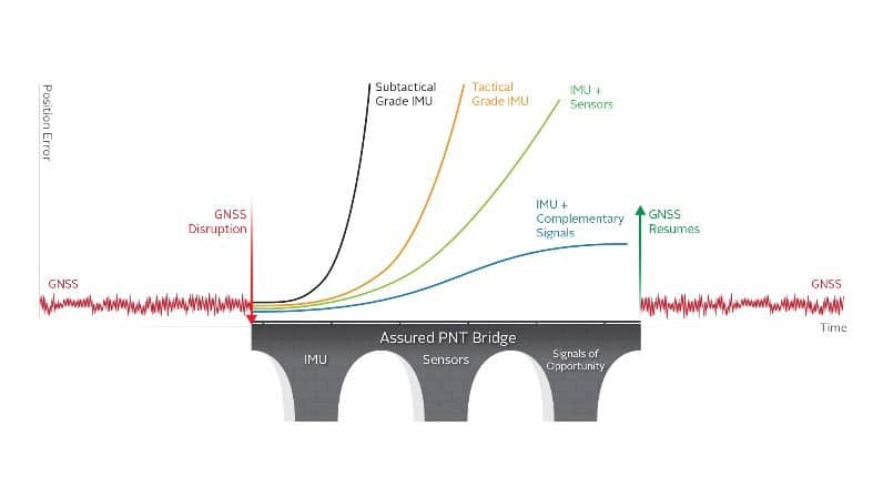
Many variables factor into building a bridge of PNT data. For example, how long can a system operate without a GNSS signal or the level of positioning accuracy needed to maintain an adequate level of situational awareness?
Consider the IMU. Even the most accurate IMU has some drift. Without GNSS present, that drift will continue and increase significantly. How drift is addressed and how the signal is augmented depends on very specific requirements. If high accuracy is needed for a short period, a sub-tactical grade IMU can be used. If high accuracy is required for a longer period, then a tactical grade IMU may be needed. Add sensors like an odometer to get PNT data for a longer period. An IMU coupled with a complementary signal provides the longest protection.
- Build in Interference Detection
GPS signal interference is widely understood as the disruption of a GPS/GNSS signal, whether from unintentional environmental factors or intentional jamming and spoofing from adversarial threats. Any interference in the continuity of the GPS signal can have dire effects on military operations, yet commanders often are not even aware that they have lost GPS signal integrity. Interference detection and warning systems automate the process of monitoring the GPS feed into receivers and the downstream subsystems relying on PNT data. These solutions even have automatic holdover protocols that can switch to alternative sources of PNT data when GPS is not available or reliable. - Augment Your PNT System
Combining data from multiple sensors (sensor fusion with Kalman filters for example) is an excellent way to augment a PNT-reliant system. It corrects for the shortcomings of individual sensors in calculating accurate positioning and orientation. Sensor fusion combines multiple signals of opportunity to develop the optimal positioning data. These signals might include GNSS, alternative signals, LIDAR, Radar, Pseudolites, MEMSMicroElectroMechanical System. See also sensors, cameras, and more.

When considering a Resilient PNT system, keep in mind that the ultimate goal is to ensure battlefield readiness, protect warfighters and stay ahead of the enemy.
